Background
It is believed that the human settlement of the site dates back to a prehistoric hill fort, successively occupied by Romans (according to the testimony of coins and tombstones recovered in area), Suebi since 411 and annexed by the Visigoths in 585. It was later attacked by the Muslims several times, at the time of the Christian À época da Reconquest of the Iberian Peninsula, from the mid-19th century 8th century. It came to integrate the domains of Gallaeciense Regnum until the independence of the Kingdom of Portugal. From that moment on it has been part of Portugal until today.
The medieval castle

Territory included in the domains of the kingdom of Portugal since its independence, the population received a Charter from Afonso III of Portugal (1248-1279), on June 9, 1273, becoming head of the so-called Terras de Barroso, the time when the construction of the castle must have begun, crossing the reign of Denis of Portugal (1279-1325) - who guaranteed the town substantial privileges in 1289, aiming at its settlement -, to be completed, in 1331, in that of Afonso IV of Portugal (1325-1357), according to the epigraphic inscription at the foot of the south tower.
At the time of the crisis of 1383-1385, the town and its castle took sides with D.Beatriz, to be incorporated, after the battle of Aljubarrota, by the forces of John I of Portugal (1385-1433) in the context from the campaign to Chaves and the north of Portugal. In this context, Barroso's lands were offered to the Constable, D.À época da Nuno Álvares Pereira .
Under the reign of Manuel I of Portugal (1495-1521), the town and its castle are represented by Duarte de Armas (Book of Fortresses, c. 1509), receiving the New Charter in 1515. A addition to the epigraphic inscription on the south tower informs us that repair works have been completed by the licentiate Manuel Antunes de Viana in 1580.
From the Portuguese Restoration War to the
present day
In the context of the Portuguese Independence Portuguese Restoration War, its value was recovered strategic-defensive on the border, the castle underwent modernization works aimed at adapting it to the then modern artillery shots.
The earthquake of 1755 did not cause any greater damage to the castle than that caused by the fall of one of the battlements, as stated in the Parish Memoirs of 1758. According to this source, in response to the general survey formulated by Father Luís Cardoso to all the parishes of the kingdom after the earthquake, the then parish priest of Montalegre, Father Baltazar Pereira Barroso, together with the priests Bento Gonçalves dos Santos and José Pereira Carneiro, dated March 19, 1758, report that the fortification, consisting of four towers connected by a wall, was defended by an outer wall and a counter-wall with a moat. Three were torn in the walls doors (north, west and south) and a wicket (between the west and south doors). Over the walls, a defensive stockade was erected.

Later, another author, Américo Costa, described the structure, also using the "Parochial Memories of 1758" as source:
- The keep, situated to the north, is 30 to 40 feet square at the base, 68 to 70 feet tall. The east measures 30 feet wide and 58 to 60 feet high, with nearly all the stones marked with various signs. The south tower is 15 feet at base and 50 feet high; and solid up to two thirds of the height; at the base, on the south side, there is the following inscription: "A. Alf. 4th Year of 1331. Retired by Ld.º Manuel Antunes de Viana. Year 1580". The west measures 15 feet wide at the base, and 35 feet high; is solid up to three quarters of the height.
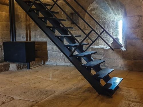
- In 1758, the house of the castle governor was built in the inner courtyard of the towers. Fr. Balthazar also refers to the cistern, bread ovens and several ladders leading up to the grounds give access to the towers; describes the ravelin next to the north gate, where one entered the courtyard, and details the defensive device of this door which was the main entrance to the fortress. It alludes to the soldiers' bunks, the officers' houses and sergeants and the stables that existed next to the castle. The second and fourth floors of the keep, which were made of wood, were in ruins. They were in the same state the upper floors, the roofs and the stakes of the walls and counter-walls of the southeast and south towers. The one in the southwest, the smallest of the four, was used to store gunpowder.
In the 20th century, the complex was listed as a National Monument, by Decree of June 23, 1910. From the 1980s onwards, public authorities' action was manifested through a campaign of intervention and restoration, which culminated in the 1990s with the installation of a nucleus museological.
In 2021, it ceased to be supervised by the Government and became the responsibility of the municipal chamber.
Architecture
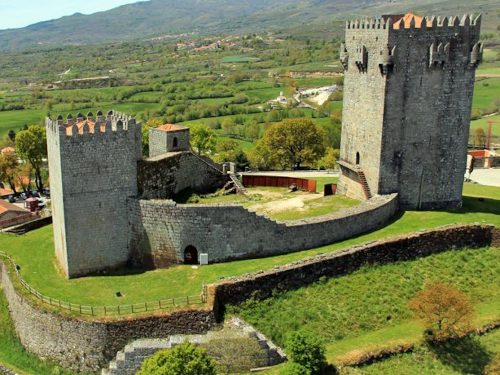
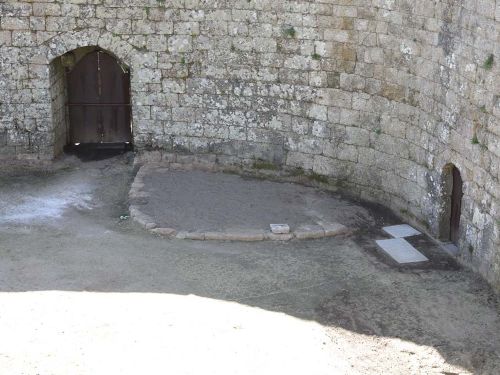
Built at an elevation of 980 meters above sea level, the quadrangular castle is made up of by four towers connected by walls, closing the parade ground. In the center of this, a cistern.
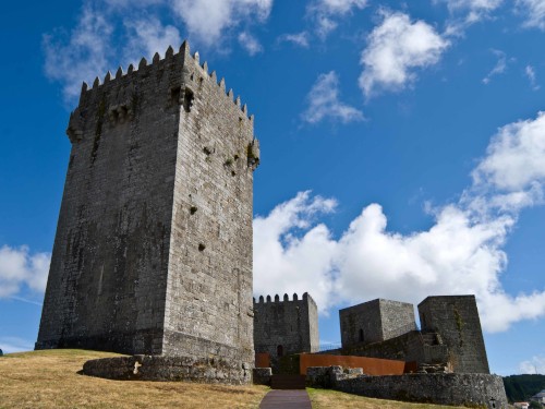
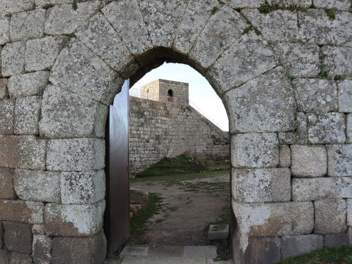
The keep, to the north, in Gothic style, rises 27 meters high, crowned by balconies of boulders, corbels and pentagonal battlements. The interior rooms feature a vaulted ceiling stonework. The Torre Furada, to the south, has a square plan. The Clock Tower and the Tower Small, also to the South, both have a rectangular plan.
Externally, the structure was defended by two lines of walls, as shown in the drawing by Duarte de Armas, now demolished. To the east and south, the medieval village developed.
Events of the time
1273 - Foundation of the city of Montalegre, in Portugal.
1275 - The Venetian Marco Polo
arrives in Beijing, China.
1278 - D. Afonso III hands over the government of
the kingdom to D. Denis.
- Independence of Andorra.
1279 - D. Dinis becomes king of Portugal.
- The first references to the Azores archipelago originate from sea
voyages made by Europeans in the 14th century,
namely from Portugal during the reigns of D. Dinis (1279-1325) and his successor,
Afonso IV.
- In Portugal, King D. Dinis begins the process of requalifying the
walls of Braga. The works will continue until around 1325.
1281 - Beginning of the armed struggle between D.
Dinis and the
infante D. Afonso, his brother.
- D. Dinis offered the town of Monforte to his daughter
D. Isabel as a dowry at
her wedding.
1282 - June 26 - Wedding, in Trancoso, of D. Dinis, King of Portugal and
Isabel of Aragon.
- Agreement between D. Dinis and his brother Afonso, in Badajoz.
Afonso promises to destroy the walls he had built, be knighted and become his vassal.
1290 - In Portugal, D.
Dinis granted
a Charter to Ourique.
1295 - Jacques de Molay assumes the position of Grand
Master of the Order of the Knights Templar.
1297 - September 12 - The Treaty of
Alcanises defines the
border between Portugal and Castile.
- January 8 - Monaco gains independence.
- September 11 - The Scots, commanded by William
Wallace
and Andrew
Moray, defeat the
English
under Edward I of England, in the
Stirling Bridge Rating.
- Foundation of the Portuguese parish of Quarteira.
- A Portuguese water dog is first described in a monk's report of a
drowning sailor, who had been pulled from the sea by a puppy.
1302 - September 26 — The templars lose the
island of Ruad which thus
becomes the last stronghold
of cruzados na Holy Land.
1305 - The Templars are threatened in France by King
Philippe the
Handsome.